
In a recent post, I discussed the controversy over the “Disappearing Palestine” Vancouver transit ads. While much of my analysis centered on the ethics of attempting to delegitimize the sovereign expression of one nation versus another, various commenters expressed the view that the maps contain lies.Let’s take a closer look at the veracity question.

It’s not the first time these particular maps have reared their head in the blogosphere. Back in 2010, bloggers Jeffrey Goldberg and Andrew Sullivan traded barbs over the maps, which Sullivan apparently borrowed from Juan Cole’s blog. As the Economist noted in its roundup of the debate, the maps fail “to distinguish between land that is owned by Jews or Palestinians, and land that is controlled by Jewish or Palestinian political entities.”
I would go a little deeper and broader than this. First, I would argue that the maps conflate the issues of state control, sovereignty, land ownership and demographics. This is what makes those on each “side” of the issue see the maps so differently. On the other hand, given that these maps are being used in the service of political debate, it’s important to look to an entirely different type of truth contained in the maps, something that might be called experiential truth—part experience, part memory, part nostalgia. Understanding these narratives is a crucial step in explaining and predicting strategic behavior.
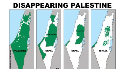
But first, let’s look at the maps’ content. The 1946 first map, showing tiny white dots against a sea of green, is the most problematic. In 1946, owing to active Zionist immigration, the population within the British-held Palestine Mandate was 30 percent Jewish (data drawn from this book, p. 571). Much of the land these Jews lived on was purchased—primarily by the Jewish National Fund—and often from absentee Arab landowners. Critics of the 1946 map might suggest that the picture underestimates the Jewish presence, and they tend to point to the fact that there was no State of Palestine—the entire territory was governed by Great Britain as the Mandatory power.
The map showing the 1947 U.N. Partition Plan is more straightforward. Accordingly, it tends to face less criticism on the basis of veracity and more on its moral implications. What one typically hears from Israel boosters, implying that the Zionists were peace-loving pragmatists while the Palestinians were the spoilers, is a reminder that the “Palestinians rejected the plan while the Jews accepted it.” The third map can be fairly criticized for conflating the pre-1967 Jordanian and Egyptian control of the West Bank and Gaza, respectively, with Palestinian rule. And the fourth map—the one emphasizing today’s fragmentation of the West Bank—confusingly blends military occupation, private residency and sovereignty.
For a class on cartography, international diplomacy and history, the criticisms of maps 1, 3 and 4 are sound. In understanding the political context, though, many of the criticisms of all four maps miss the point. Those who point to the fact that in 1946 Palestine comprised the British Mandate rather than being a state of its own are implying that, because it wasn’t a sovereign state, the area was anyone’s for the taking—especially for the Jews who were enacting a return of Biblical proportions. Those who stress the Palestinian rejection of the U.N. proposal seem to imply that but for the intransigent Arabs, there would today be a two-state solution, and 60 years of bloody conflict might have been averted. Those who stress that Jordan and Egypt—rather than a Palestinian regime—ruled those territories are attempting to remind the world that the creation of a Palestinian state today would be a net new gain, not the restoring of a loss.
But as soon as we train our lens on narratives, we get a fuller picture. For Palestinians, the U.N. Partition Plan never seemed a fair bargain. Dividing a territory that felt like theirs—whether or not it had sovereignty attached to it in the modern sense of the word—seemed more akin to an amputation than a just compromise. This perception has only hardened since.
Similarly, while the West Bank and Gaza were in Jordanian and Egyptian, rather than Palestinian, hands until 1967, the fact that these territories were ruled by Arab states—rather than by a Jewish State that seems to vacillate between seeking permanent occupation and permanent, apartheid-like annexation—represents to Palestinians the dashed hope of self-determination, however flawed the memory given the fraught relationship with those regimes. And looking back to 1946 is, more than anything else, a statement about the trauma of exile and dispossession that lives on in the symbol of what are today millions of Palestinian refugees.
One need only read Palestinian poetry to understand the collective longing for the pre-1948 land of Palestine that defines the Palestinian collective imagination. In that battle for sovereign expression, by dint of diplomacy, organization and military acumen, the Zionists won handily. Had the tables been turned, and a State of Palestine formed while a portion of the Jewish residents were exiled and the remaining Diaspora Jews were still pining for return, one could easily picture a twenty-first century Zionist poster campaign called Disappearing Zion. It, too, would probably be fuzzy on its historical message. But it, too, would likely carry the weight of human experience, memory and imagination.


